3 Reasons Why The Map Of Oahu And Honolulu Is A Bureaucratic Nightmare
I had my physical map spread across a sticky patio table in Waikiki. Morning humidity was already curling the edges of the paper. The air smelled like a confusing mix of expensive coconut sunscreen and diesel bus exhaust. My eyes burned from screen glare at 1:30 AM last Tuesday. Plunging into the digital void to research Oahu and Honolulu means three tabs open, four conflicting Reddit threads, and a lukewarm cup of motel coffee smelling faintly of burnt plastic.
As a VisitFlorida Travel Partner since 2018, I am used to navigating swamps where alligators have the right of way. I thought I knew chaotic geography. Florida mud and water are surprisingly easy to read. But trying to map out a Hawaiian vacation humbled me entirely. I spent days wondering why blogs toss the island name and the city name around interchangeably. The internet is a messy place. We are cutting through the noise.
Reason 1 The Government Consolidation Glitch
According to the official Honolulu city government, the local jurisdiction is a consolidated city-county. That legal boundary covers the entire island. Bureaucracy is fun. You think you are looking at a map of a city on a rock. In reality, the legal city is the entire rock. If you try to find the edge of the municipal boundary by drawing a line around the skyscrapers, you fail immediately. Beige travel is a tragedy because it refuses to explain administrative headaches like this.
Reason 2 The Illusion Of Suburbs
Because the government treats the entire landmass as one zone, geographic lines are completely blurred. You can drive an hour north, feeling the heavy salt spray of crashing surf sticking to your arms, and you are literally still in the same city. Glossy travel magazines treat places like Kailua or Haleiwa as entirely separate, distinct towns. Technically, those are just neighborhoods under the exact same mayor.
Reason 3 The Transit Monolith Setup
This is precisely why researching transit here breaks your brain. The local island network is simply called TheBus. Because there are no distinct county lines, there are no confusing regional transit handoffs. I dug through 80 pages of municipal zoning codes so you do not have to. 2019 me would have panicked trying to map out different transit zones with highlighters. 2026 me knows it is just a government labeling quirk. You pay your fare, and the screeching brakes of the bus will take you from a high-rise to a rugged jungle trail.
5 Reasons Why Booking Tours Between Oahu And Honolulu Will Break Your Brain
If you blindly trust a map to book your excursions, you are walking into a trap. I read the hostile 1-star TripAdvisor reviews from 2018 tourists screaming about distances. Research is my love language; reality is my ex. You just want sideways rain in your hair and a paddle in your hands. But getting to that paddle requires surviving the logistics.
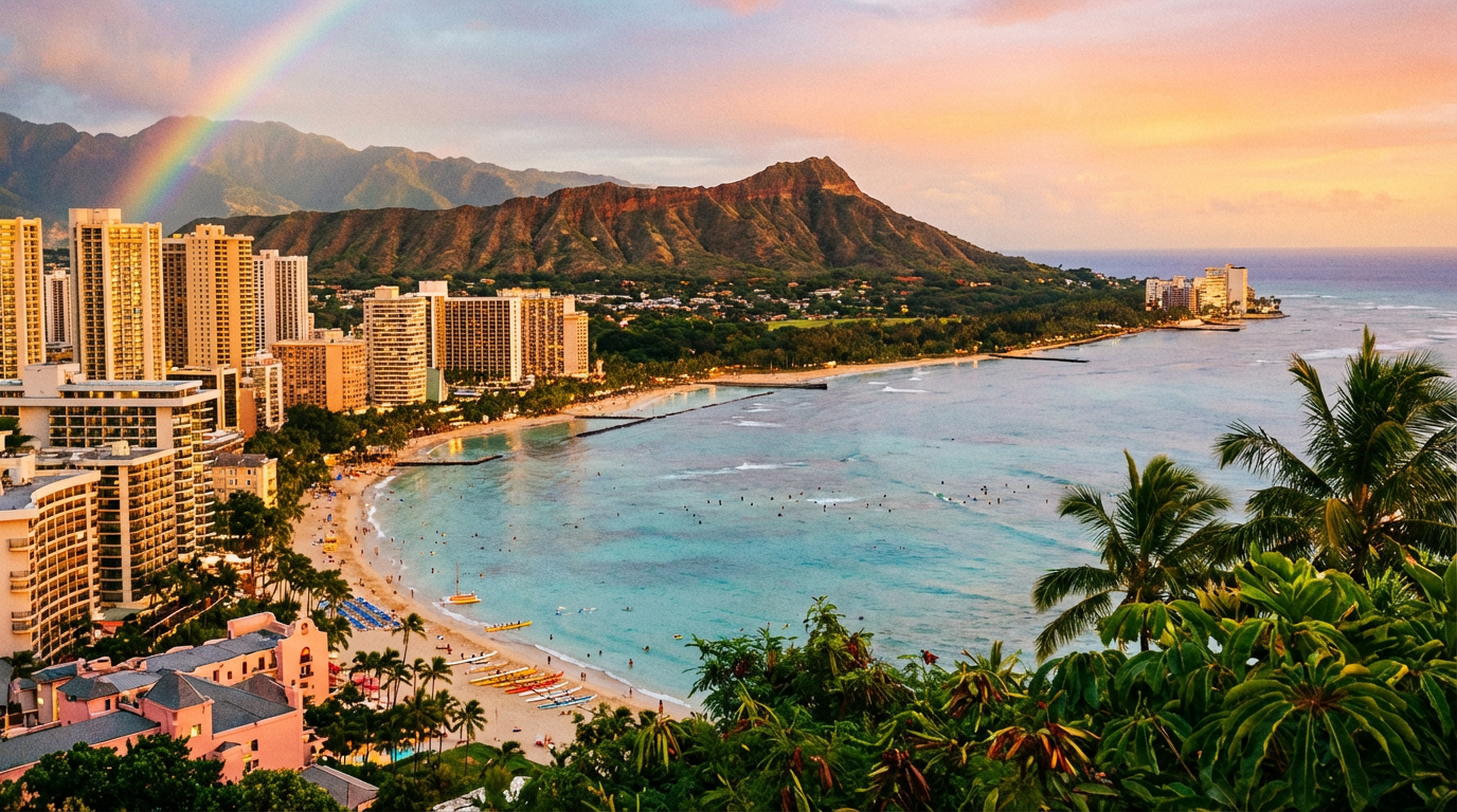
Reason 1 The Lava Geography Trap
You want to see active, bubbling lava on this island? I hate to break it to you. You are out of luck. The famous Diamond Head crater looming over downtown is as dead as a doornail. I spent three hours last Tuesday reading frantic forum posts from tourists asking for driving directions to lava flows from their downtown hotels. I cannot prove this, but I think tour operators secretly love watching visitors search for a municipal bus to a volcano.
Reason 2 The Brutal Inter Island Commute
Here is the messy truth about booking a Honolulu Volcanoes National Park tour. You are not buying a bus ticket out of the city limits. You are actually buying a tiny commuter plane ticket. The morning departure is an intense sensory experience. First, the aggressive icy blast of airport AC hits your face. Then comes the sharp smell of burnt jet fuel mixing with the sticky 6 AM tropical air. You will question your life choices before the coffee even kicks in.
Reason 3 The Driving Distance Deception
Even if you stay on the island, the map lies about driving times. A digital line between Oahu and Honolulu points of interest looks like a short 20-mile jump. In reality, you are battling the H-1 freeway. The physical sensation of sitting in paralyzing, exhaust-choked gridlock while staring at a pristine turquoise ocean is deeply infuriating. If it's on a postcard, it's a trap.
Reason 4 The Secret Micro Climates
You pack for one city, but you are actually packing for three different climates hidden inside that city limit. Waikiki is intensely hot, radiating heat off the pavement. Drive 30 minutes to the Nuuanu Pali Lookout, and the wind whips so violently it physically pushes you backward. The temperature easily drops 15 degrees. Trust your gut on this. Always carry a jacket, even if your weather app promises sunshine.
Reason 5 The County Naming Misnomer
Wait, what? This is the massive pivot that completely broke my understanding of this map. Let's say you see an obscure wildlife tour listed in Honolulu County. You might assume it is a short drive from your resort. Look closer. The jurisdiction of Honolulu County stretches far beyond the populated island into the absolute middle of the Pacific Ocean.
4 Reasons Why I Was Dead Wrong About The Oahu And Honolulu Borders
I dragged a blue ink pen along the southern coast of my paper map, tracing the logical city limits. I thought I had it completely figured out. The city hugged the beaches. The rest was wild terrain. Simple. Clean. Totally wrong. You can fight the geography, but the Pacific Ocean always wins.
Reason 1 The 1350 Mile Border Reality
I tapped my phone screen to zoom out past the shoreline. And I kept zooming. According to the National Oceanic and Atmospheric Administration, the legal border of this city extends over 1,350 miles northwest into the ocean. That is roughly the driving distance from New York to Miami. Except here, it is endless saltwater and protected monk seal habitats. Let that sink in for a second. The city is massive.
Reason 2 The Empty Green Space Deception
Looking at a digital terrain view, the center of the island looks like a massive empty park. A perfect shortcut from the south shore to the north shore, right? Wrong. That green blotch is the Koolau Mountain Range. It consists of near-vertical, impassable volcanic ridges that feel jagged and sharp to the touch. The map tricks you into thinking you can drive straight through. The reality forces every single rental car onto just two narrow highways.
Reason 3 The Uniform Tax Code
Because the government lines are practically nonexistent on the island itself, everything falls under one umbrella. Whether you are paying taxes on a distinctly pungent Kahuku garlic shrimp plate on the rural north shore or buying sunscreen downtown, the municipal rules are identical. You never cross a line where the local laws abruptly shift.
Reason 4 The Disconnect Between Vibe And Governance
The energy is wildly different depending on where you stand. The gritty, wave-battered North Shore feels like a lawless surfing outpost. The downtown area smells of expensive sushi and bleached hotel linens. Yet, surfers and corporate suits answer to the exact same municipal council. My 2018 brain could not process how such opposing energies existed under one local government.
3 Reasons Why My 2026 Strategy For Oahu And Honolulu Will Save Your Trip
2019 me thought booking a Waikiki hotel meant I could walk everywhere. I pictured myself grabbing cold, sweet shave ice and casually hiking up to a molten crater by noon. 2026 me knows that was a beautiful, naive trap. Florida travel distances are measured in miles. Hawaiian distances are measured in TSA lines and mountain weather delays.
Reason 1 Stop Searching Municipal Lines And Use Curated Platforms
Instead of fighting arbitrary county zoning maps and guessing if a tour is literally on your island, use a filter that actually works. Browse real, location-verified listings through Rockon Recreation Rentals. The geographical guessing game is gone. You will not accidentally book a helicopter dive on an island you are not even visiting. Let that ease your mind entirely. Focus on wiping sticky salt air off your phone screen before the sea turtles swim away.
Reason 2 Pack For Three Distinct Elevations
Do not let the tropical latitude fool you into complacency. If you hop over to the Big Island for an excursion, be prepared for shock. According to NPS weather data, summit temperatures at the volcanoes easily drop into the low 50s. I shivered violently next to a steam vent smelling of sulfur just last month. The rough basalt rock crunches underfoot like broken glass. I go where the signage is bad and the coffee is good, but I distinctly learned to wear layers doing it.
Reason 3 Keep Your Daily Itinerary Excruciatingly Loose
You can build a beautiful spreadsheet mixing days exploring Oahu and Honolulu borders. A sudden tropical squall will shred that spreadsheet in three minutes. You will physically feel the pelting rain soaking right through your canvas shoes. Listen to local tour operators when they warn you about delays. They know the barometric pressure drops better than your shiny weather app. Beige brochures demand perfect planning. Reality demands flexibility. You just have to accept that the map is lying to you, drop the pen, and enjoy the chaos.