The Truth About Utah Roads Between December And February
Wondering is it safe to drive from slc to canyonlands in winter before renting vehicles? As VisitFlorida Travel Partners expanding our outdoor tours to Utah since 2018, we spot overconfident out-of-state drivers instantly. The famous Utah powder drops precisely when you least expect it, coating the asphalt with hazardous layers that trap unprepared motorists daily.
U.S. Route 6 often looks completely clear for 50 straight miles descending from Salt Lake City. Then, travelers consistently hit a dangerous stretch of black ice near the 7,474-foot Spanish Fork Canyon summit. Piloting a 4,000-pound rental SUV at 65 miles per hour requires serious local winter road awareness and precise mechanical grip.
This late 2026 winter season brings volatile 30-degree temperature swings across the high desert terrain. So, is it safe to drive from slc to canyonlands in winter? The answer requires evaluating your specific all-wheel-drive equipment, tire specifications, and emergency supplies. Let's break down the strict realities of conquering Highway 191 versus booking professional guided transport.
How High Altitude Alters The Road Surface
The 230-mile journey from Salt Lake down to Moab changes rapidly in elevation. You start at roughly 4,226 feet in altitude near the airport and climb well past 7,474 feet at Soldier Summit. That substantial 3,248-foot elevation gain drastically alters pavement surface temperatures, often resulting in invisible freezing zones.
Quick whiteouts routinely catch travelers completely off guard in that specific mountain pass. According to the Federal Highway Administration, adverse winter weather significantly increases the risk of traction-loss accidents in high-altitude mountain corridors compared to valley roads. The pavement temperature typically drops 10 degrees faster than the surrounding atmospheric air, freezing ground moisture before flurries even begin.
Black ice dictates the true risk level on this specific route. It rarely appears as a frozen, white hazard. Instead, it mimics a wet, shiny puddle stretching across the dark asphalt, tricking drivers into maintaining highway speeds.
Here is a practical technique from our daily drivers at Rockon Recreation Rentals. If the road spray from the semi-truck tires operating ahead of you abruptly stops, decelerate immediately. That dry spell on a damp road typically means the surface moisture froze solid at 32 degrees Fahrenheit.
- Watch your external vehicle thermometer. When the outside ambient air drops to 36 degrees, suspended bridge decks freeze first due to wind passing underneath.
- Keep following distances exceptionally wide. Leave a full ten seconds of following distance on 6% downhill mountain grades.
- Never use cruise control in the mountains. Engaging cruise control over black ice at 60 mph triggers immediate, unrecoverable mechanical spinouts.
Understanding Fast Moving Winter Storm Systems
A sunny morning in the Salt Lake Valley can devolve into a complete whiteout blizzard by lunchtime in the canyons. The steep Wasatch Plateau forces heavy storm systems violently upward. As moist Pacific air rises 5,000 feet, it cools rapidly and routinely drops two inches of snow per hour over the asphalt.
Experts at the National Oceanic and Atmospheric Administration (NOAA) define this natural atmospheric process as orographic lift. Broad, towering mountains literally squeeze the moisture straight out of passing weather fronts directly onto your driving path.
This atmospheric effect creates severe roadside edge cases. You might battle a heavy, blinding blizzard in Price, only to reach bone-dry pavement 60 miles south near Green River. The abrupt, 60-minute geographic shift frankly shocks most out-of-towners expecting uniform weather.
We always verify the live traffic cameras before operating daily tours. When determining is it safe to drive from slc to canyonlands in winter, continuous tracking of active 2026 storm cells provides the only accurate answer. Never assume a clear morning departure translates to safe passage down to Moab.
Managing Your Winter Drive From Salt Lake City To Canyonlands
Managing the physical highway descent demands strict attention to shifting microclimates. Since our early days leading warm Florida adventures (including the Florida Airboat Safari) back in 2018, we learned you never ignore incoming radar fronts. That golden rule applies directly to navigating 7,000-foot Utah mountain passes.
According to Tripadvisor community forum data, the journey offers striking, snow-dusted red rock vistas when the skies clear. Under optimal dry conditions, this 230-mile road trip takes approximately four hours. You simply hop on Interstate 15 South, merge onto Route 6 East, and follow the 75 mph speed limits until you reach Interstate 70.
Evaluating Travel Time During January Storms
What happens when a sudden January atmospheric river rolls in? A heavy snowstorm easily adds two to three hours to your standard arrival time. Sometimes delays stretch even longer if the active state snowplows fall behind schedule on the 6% gradients approaching Helper.
Those specific delays trigger the ultimate traveler question. Specifically, is it safe to drive from slc to canyonlands in winter if flurries start? The reality involves respecting local mountain forecasting daily and adjusting your itinerary without hesitation.
In the 2026 season, rapid storm cells frequently trap unprepared drivers in deep roadside drifts. If you plan to rent outdoor gear through Rockon Recreation Rentals, allot an extra 90 minutes of buffer time. Reaching your trailhead late heavily outweighs paying a $300 to $400 rural tow truck fee.
Check the official highway cameras before departing your hotel. The Utah Department of Transportation (UDOT) updates high-altitude road conditions roughly every five minutes. Top off your gas tank in Provo, as major 24-hour stations vanish quickly past the Interstate 15 junction.
Navigating Spanish Fork Canyon Crosswinds
The 20-mile stretch of U.S. 6 climbing southeast away from Spanish Fork channels brutal crosswinds directly across the travel lanes. Those steep, 1,000-foot canyon walls act like a massive natural wind tunnel, magnifying existing storm fronts.
We observe nervous travelers legally turning around at the canyon mouth every single winter. Delaying travel by two hours entirely beats managing a white-knuckle panic attack. Crosswinds theoretically push lightweight crossovers dangerously close to the center median on icy curves.
According to the National Weather Service, canyon wind squalls frequently surpass 40 miles per hour during peak winter fronts. That exact force instantly blows blinding, loose powder across the dark asphalt. Steering a vehicle on an ice rink with zero visibility dramatically elevates your risk of a collision.
Patience serves as your absolute best defense on this twisty section of road. If traffic drops to a 15 mph crawl, crank your cabin heat to 72 degrees and maintain calm. Give those massive 10-wheel UDOT snowplows at least 200 feet of following distance, and never attempt to pass them on the right.
Ultimately, is it safe to drive from slc to canyonlands in winter during a 40 mph canyon windstorm? We strongly suggest delaying your departure. Let the highway crews salt the black ice first before risking a slide.
Vehicle Requirements For Conquering Highway 191
Pushing a stuck, front-wheel-drive sedan up a frozen 5% grade ruins your afternoon completely. Travelers constantly message our desk asking, is it safe to drive from slc to canyonlands in winter with a standard airport rental car?
Your baseline safety depends wildly on your chosen vehicle classification. Since 2018, we have watched unprepared families tackle 7,000-foot passes in basic compact cars. Those lightweight economy vehicles rarely maintain forward traction over Soldier Summit during an active storm cell.
What most regional visitors fail to realize is standard airport fleets typically run cheap all-season tires designed primarily for fuel efficiency. You must formally request severe-weather equipment prior to your terminal arrival.
Standardizing All Wheel Drive For Safety
Securing a vehicle with true all-wheel drive (AWD) or four-wheel drive (4WD) remains practically mandatory. We consider it a strict requirement for traversing Highway 191 this 2026 winter season. Six inches of fresh powder accumulates remarkably fast on elevated canyon roads, burying two-wheel-drive chassis instantly.
Last December, a nervous out-of-state visitor arrived at our launch site in a tiny hatchback with minimal ground clearance. We immediately directed her to exchange it for a proper AWD SUV before proceeding south into the remote desert.
According to safety data analyzed by NHTSA, AWD systems actively mitigate wheel slippage during initial acceleration. The vehicle computer dynamically routes engine torque to whichever specific tire holds the most physical grip on the slushy surface.
However, AWD does zero favors for your downhill braking distance. Believing AWD stops a 4,000-pound car on ice is a dangerous, widespread misconception. It only helps propel the mass forward without spinning the rubber; your brakes do all the stopping.
Verifying Winter Tire Safety Marks
Proper tire rubber strictly dictates traction more than a powerful V8 engine. You can rent a heavy 4x4 truck, but bald tires turn it into an unguided sliding missile. The identical logic applies when towing heavy off-road assets like a Polaris RZR Rental Salt Lake County, Utah.
Walk completely around your assigned vehicle in the parking garage before accepting the keys. You must scan the rubber sidewalls for a very specific industry safety mark. Look closely for the Three-Peak Mountain Snowflake symbol stamped clearly on the outer edge.
That specific symbol verifies the proprietary rubber compound remains soft and grippy even at 20 degrees Fahrenheit. According to consumer tests published by Car and Driver, these winter-rated tires outperform standard all-seasons significantly in controlled stopping tests on packed powder.
Regular all-season tires harden into slick hockey pucks below 45 degrees. Our staff at Rockon Recreation Rentals utilizes a practical quarter test. Place Washington's head upside down directly into the center tire groove.
If you can see the very top of his head, your tread sits below the recommended 4/32 of an inch for snow travel. March right back to the desk and demand a different car. Spending five minutes measuring exact tread depth highly prevents a slide into a snowy embankment.
Complying With UDOT Winter Traction Laws
During active 2026 weather events, the Utah Department of Transportation implements strict Class I and Class II traction laws over high-elevation passes. When Class II restrictions drop, merely having AWD no longer satisfies the rigorous legal requirements.
Highway Patrol physically inspects passing vehicles for the severe snow rating or actual tire chains. Failing to meet these strict state legal standards results in a mandatory turned-around vehicle and potential roadside citations.
Many out-of-state drivers renting standard sedans from the Salt Lake City airport completely miss this crucial regulatory detail. Traveling without approved chains during a Class II restriction effectively strands your group hundreds of miles from the intended destination.
Emergency Supply Planning For The High Desert Route
Do you find yourself second-guessing and wondering, is it safe to drive from slc to canyonlands in winter? The route remains highly secure, provided you plan exactly like a seasoned local resident. High-desert weather systems frequently drop ambient temperatures 20 degrees in roughly twenty minutes.
A dry, 50-degree highway morphs into a slick snowdrift near Monticello incredibly fast. We have safely guided out-of-state guests through these specific 230 miles since 2018 by respecting harsh atmospheric realities.
Let's outline the stark remoteness of the central Utah desert. The barren 62-mile stretch connecting Price and Green River contains zero operating 24-hour gas stations. According to travel warnings by Lonely Planet, cellular data connections often drop completely as you approach the massive shale formations of the Book Cliffs.
Managing Fuel Across A 62 Mile Outback Stretch
The paramount rule for traversing rural desert highways involves your fuel gauge. You must realistically refill your vehicle the exact second your gauge hits the halfway mark. Flatlanders and city natives routinely disregard this precaution, creating dangerous stranding scenarios.
Why does crossing the 50-percent line carry such high risk during the 2026 season? Because a basic local tow truck easily requires 180 minutes to reach remote mile markers. If a jackknifed semi shuts down Route 6, your idling engine supplies your only life-saving cabin heat.
According to survival guidelines from the National Park Service, severe desert cold drops human core temperatures to dangerous hypothermic levels within an hour of exposure. Maintaining four gallons of reserve fuel runs your 12-volt heater safely all afternoon.
Our Rockon Recreation Rentals crew recommends a non-negotiable pit stop. Pull over at the major gas stations in Wellington just off U.S. 6. It serves as your final reliable commercial bathroom and fuel pump before civilization vanishes completely.
Assembling A Practical Desert Survival Kit
Do your future self a massive favor before breaking the Salt Lake City limits. Toss a thick 20-degree rated sleeping bag and 2,000 calories of dry food into the backseat. Consuming trail mix in a relatively warm car entirely beats freezing while waiting on backlogged roadside assistance.
Last January, a visiting Chicago family sat stuck near Spanish Fork for three solid hours. A commercial 18-wheeler spun out on unexpected black ice, barricading both southbound traffic lanes entirely and halting dozens of cars.
Because they proactively packed bottled water and high-protein snacks, their potential survival scenario downgraded into a mildly boring wait. Rapid cold fronts promise volatile 30-degree temperature drops this current season, plunging idling cars into a deep freeze.
So, is it safe to drive from slc to canyonlands in winter without any physical survival supplies? We definitively say no. Always store two gallons of drinking water, as blasting auto heaters dehydrates the human body at roughly double the normal rate. Carry a commercial, heavy-duty snow shovel to dig out frozen slush if you slide off the shoulder.
Strategy For Unexpected Highway Barricades
State troopers deploy physical barricades across Highway 6 in less than ten minutes. You might be cruising safely when a sudden line of flashing red lights stops your forward momentum at the base of the canyon.
When volatile 2026 storms dump two inches of snow per hour, officials close these canyons completely to prevent mass vehicular pileups. Stranded drivers frequently call us from the roadblock, panicking and asking, is it safe to drive from slc to canyonlands in winter during an active whiteout?
When heavy steel gates drop across the asphalt, the strictly enforced answer is no. Highway patrol utilizes those specific closures to halt traffic on 6% gradients where gravity overpowers tire friction. You simply must wait for the weather cell to break.
Utilizing Live Traffic Data For Safety
If you are crossing county lines, the official UDOT smartphone app acts as an essential digital lifeline. It accurately tracks over 500 state snowplows via GPS in absolute real time. That empirical data easily outperforms relying on standard mapping applications during an intense blizzard.
According to road physics outlined by the Federal Highway Administration, surface temperature sensors embedded in the asphalt provide crucial freezing data. You actively monitor live 1080p road cameras to visually verify whether the 7,474-foot summit looks clear before proceeding.
Refuse the intense urge to find a clever, unpaved gravel shortcut to bypass the gate. Your generic digital GPS might aggressively reroute you onto a treacherous ranch road. Since 2018, our guides rescued numerous out-of-towners who blindly followed automated maps into remote Bureau of Land Management (BLM) dirt tracks. Recovery winches from those ravines cost upwards of $400 out of pocket.
Finding Warm Shelter During Active Closures
What constitutes a highly effective game plan when state troopers halt your progress? Gracefully accept the temporary travel delay. The safest play involves tracking down a local heated diner entirely off the main highway.
Last winter, an excited family renting gear from Rockon Recreation Rentals hit a hard barricade closure near Helper, Utah. Instead of aggressively pacing around their icy rental vehicle, they located a historic Main Street cafe to safely wait out the deep freeze.
By the time they settled their breakfast bill, the stubborn storm cell had completely evaporated. The state's massive dual-blade plows clear six-inch accumulation surprisingly fast once the snowfall rate significantly decreases.
Keep your gas tank full while waiting, as idling a V6 engine burns roughly half a gallon of fuel hourly. Never park 10 feet from the physical barricade, because restricting space blocks massive 10-wheel plows from attempting their complex turnaround maneuvers.
Why Guided Tours Outperform DIY Driving
Let's embrace some honest reality regarding desert winter vacations. Gripping a steering wheel for 230 miles while battling a Utah snow squall completely drains your physical and mental energy. A premium holiday should not feature a high-stakes emergency stress test on black ice.
Anxious visitors spend late nights scrolling forums before embarking on northern routes like a Luxury Private Grand Teton National Park Full-Day Tour, or tackling the southern Moab desert. They persistently ask, is it safe to drive from slc to canyonlands in winter when relying on zero local mountain experience?
The practical truth is you can totally bypass the driving risk by booking Salt Lake City Canyonlands Tours. Instead of rigorously calculating downhill braking distances on icy 6% grades, you simply hire a local commercial professional who knows the route flawlessly.
Taking Advantage Of Commercial Driver Muscle Memory
Attempting lane changes in a rental sedan during a zero-visibility Highway 191 whiteout spikes your cortisol levels instantly. Securing a commercial guided tour guarantees seasoned veterans handle the massive 4,000-pound vehicle dynamics.
Our licensed operators clock thousands of miles over these specific mountain passes during the 2026 winter season. They memorize exactly which shaded, north-facing curves develop black ice at 3:00 PM. They react to losing rear-wheel traction automatically, deploying corrective steering without panic.
According to the Federal Motor Carrier Safety Administration (FMCSA), properly trained commercial operators record significantly lower crash rates in adverse weather conditions compared to standard motorists. Relying on highly practiced muscle memory mitigates your inherent travel risk dramatically.
You easily skip the exhausting panic of slipping tires on steep 7,000-foot summits. Explore the vetted commercial transport options at Rockon Recreation Rentals to convert treacherous driving into a comfortable sightseeing nap.
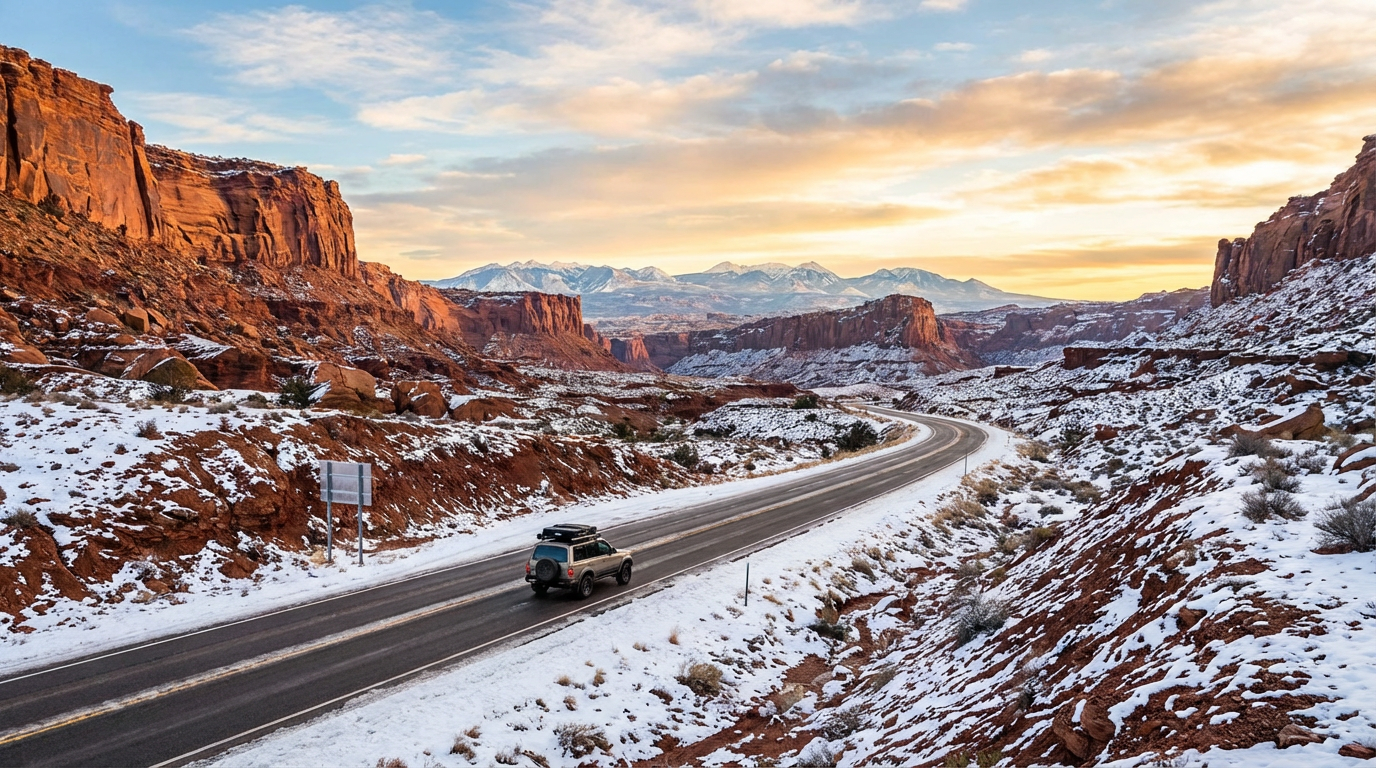
Photographing The La Sal Mountains Safely
Relinquishing the steering wheel reveals a massive aesthetic perk. You actually witness the 230 miles of world-class, snowy red rock scenery instead of staring intensely at the bumper ahead of you through a frosted windshield.
Sitting securely in a heated passenger van allows you to absorb the towering 400-foot sandstone cliffs. The stark visual contrast of bright white powder dusting deep crimson mesas creates unparalleled photo opportunities that drivers entirely miss.
According to visitation statistics from the National Park Service, Canyonlands hosts roughly 100,000 off-season visitors specifically seeking these pristine, snow-capped landscapes. You get to socialize, hydrate, and capture crisp photography flawlessly without managing an icy steering wheel.
Cargo Inventory Strategies For Highway 191
Mitigating road risk strictly demands evaluating your actual trunk inventory before leaving town. When concerned tourists ask, is it safe to drive from slc to canyonlands in winter, we immediately inspect their vehicle payload at the rental office.
If you purely pack a $5 plastic ice scraper and a spare water bottle, you severely underestimate Route 6. Surviving the 2026 frost absolutely requires acknowledging highly localized, aggressive storm cells and keeping recovery tools accessible.
Equipping A 30 Inch Aluminum Avalanche Shovel
A designated, 30-inch aluminum avalanche shovel serves as your ultimate backcountry recovery asset. Discard those flimsy plastic gas-station shovels immediately, because brittle plastic shatters into useless shards the millisecond it strikes frozen Utah mud.
Hoist a 20-pound abrasive bag into the trunk directly over your rear axle to enhance kinetic traction. If your four tires begin a high-RPM spin over fresh glaze on Soldier Summit, kill your vehicle acceleration instantly.
Exit the vehicle safely and spread heavy grit directly under the specific drive wheels for instantaneous grip. Purchase the cheapest clay cat litter available, because advanced clumping formulas morph into slippery slime on black ice. Following strict winter guidelines published by Ready.gov, insulated gloves and commercial chemical heat packs remain absolutely crucial emergencies supplies.
Bypassing Cellular Dead Zones
Glaring at a frozen cell phone map screen while snow aggressively coats your windshield triggers genuine highway panic. Modern 5G cellular coverage completely drops out inside these deep geological formations south of Price.
You will seamlessly stream playlists while exiting the Salt Lake City limits. But the precise second you descend into Spanish Fork Canyon, your digital map goes completely blank. That exact technological blackout strikes again on Highway 191 approaching the Green River crossing.
Always store a folding topographic paper map physically inside your glovebox. Topographic guidance experts at USGS consistently warn that towering 400-foot sandstone canyon walls severely inhibit satellite GPS reception and block emergency signals.
Conclusion Making The Right Call For Your Winter Trip
Ultimately, figuring out is it safe to drive from slc to canyonlands in winter hinges entirely on your specific trip preparation, cargo supplies, and defensive driving background. The 230-mile trek from the Wasatch Front down to the high desert demands profound respect for black ice, rapid atmospheric temperature drops, and remote cellular dead zones.
Standard sedans outfitted with bald all-season tires transform a scenic 2026 holiday into a stressful, hazardous trial. Upgrading to a properly equipped AWD vehicle featuring 3PMSF-rated tires dramatically boosts your safety, provided you actively measure tread depth and rigorously monitor UDOT traction laws.
As VisitFlorida Travel Partners operating Rockon Recreation Rentals, we highly suggest bypassing the extreme stress entirely. Trusting local professionals who navigate these exact mountain passes daily converts your journey from a white-knuckle endurance test into a relaxed, visually striking sightseeing experience. By leveraging guided commercial tours, you guarantee your canyonland vacation remains memorable strictly for the right reasons.
Top Rated 2026 Winter Excursions
Ready to hit the trail without the hassle of driving? Browse some of our fully guided adventures below to turn complicated winter logistics into secure, lasting memories.