Planning your arizona adventures systematically in 2026 is the only reliable way to guarantee access to highly restricted public lands. Ever wonder why unprepared travelers get completely overwhelmed out west? They try to rely on spontaneity in a region that demands strict geographic and meteorological logistics. As a professional Florida outdoor guide mapping backcountry routes since 2018, I am thoroughly accustomed to managing spontaneous humid wetland trips in the Everglades, but the vast, arid scale of the American Southwest requires a drastically tighter operational strategy.
Last spring, a colleague drove 115 miles north of Phoenix without securing a specific activity permit, expecting to find flexible open parking at popular Yavapai County trailheads. Instead, he encountered a 45-minute stagnant traffic bottleneck on Highway 89A and discovered that every single US Forest Service recreational lot reached absolute physical capacity by 8:00 AM. Navigating this immense landscape requires acknowledging that modern wilderness access runs on digital reservations and precise temporal coordination.
As a verified Rockon VisitFlorida Travel Partner, I consistently analyze regional traffic patterns to help coastal visitors transition safely into desert biomes. Relying on an unstructured itinerary leaves you vulnerable to severe supply scarcity, immediate physiological heat stress, and total communication blackouts once you leave the interstate pavement.
Reason 1 Securing Permits Before Walk Up Quotas Vanish
Protected backcountry areas across the Southwest operate under strict daily entry quotas explicitly designed to prevent heavy geological erosion on delicate sandstone formations. According to the US Forest Service infrastructure reports, the Coconino National Forest region alone manages roughly 4 to 5 million visitors annually, forcing administrators to aggressively cap daily mechanical and pedestrian entry limits.
Because of this concentrated volume, attempting to secure a spontaneous walk-up permit during the peak 2026 travel season yields a statistical success rate of less than 12 percent for top-tier trailheads. If you arrive at an access gate without digitally verified commercial reservations or pre-printed government lottery permits, park rangers stationed at the checkpoints will routinely force you to execute a U-turn.
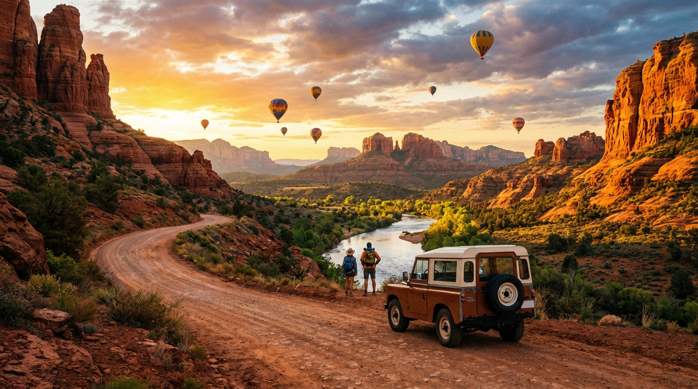
Booking a specialized activity through a verifiable platform establishes an immovable anchor point for your daily itinerary, completely preventing desert decision fatigue. Pre-arranging excursions like a Guided ATV Tour Sedona guarantees legal ingress to restricted red rock corridors without requiring you to compete physically with thousands of other vehicles at dawn.
Reason 2 Beating The 105 Degree Heat Threshold With Morning Staging
Desert surface temperatures dictate your entire outdoor schedule, completely overriding standard leisure vacation hours. During the summer of 2026, baseline afternoon air temperatures routinely exceed 105 degrees Fahrenheit in the lower canyon basins surrounding the Colorado River.
According to safety alerts published by the National Park Service, severe heat exhaustion remains the top medical hazard for unacclimated visitors attempting steep grade descents strictly between the high-risk window of 10:00 AM and 4:00 PM. Sedimentary canyon walls actively absorb and radiate solar energy, meaning the physical trail surface often registers 20 degrees hotter than the ambient atmospheric reading.
To outmaneuver this thermal reality, professional operators uniformly launch their initial overland vehicle stages exactly at 7:00 AM. This precise timing ensures your arizona adventures conclude comfortably before the atmospheric UV index hits its critical maximum threshold directly at solar noon (12:30 PM local mountain standard time).
Reason 3 Managing Cellular Dead Zones With Offline Topographical Data
Mainstream commercial cellular networks practically evaporate the moment you venture more than three linear miles past primary interstate corridors like I-17 or I-40. Relying on live-streaming consumer map applications often leaves drivers functionally stranded on unmarked, unmaintained Bureau of Land Management (BLM) dirt grids.
Standard municipal navigation algorithms routinely mislabel rugged, high-clearance 4x4 trails as standard passenger vehicle shortcuts. To avoid sinking a rental sedan into deep sand washes, successful trip planning requires downloading offline topographical track files via specialized software like Gaia GPS or OnX Offroad long before leaving your hotel WiFi network.
Furthermore, locking in a pre-planned route prevents families traveling in multiple vehicles from separating in environments featuring zero communication infrastructure. When you coordinate exact longitude and latitude rally points ahead of time, a lost cell signal on US Route 163 no longer escalates into a disorganized roadside emergency.
Reason 4 Mitigating High Altitude Cardiovascular Strain
Visitors traveling from sea-level coastal plains constantly misjudge the extreme topological elevation of northern desert plateaus. Driving from Phoenix up to Flagstaff drastically shifts your physical baseline from 1,086 feet to nearly 7,000 feet above sea level in less than two hours.
At 7,000 feet, the atmospheric humidity flatlines at roughly 10 percent, causing human sweat to evaporate instantaneously before it ever dampens your clothing. This rapid evaporation clinically tricks your neurological thirst mechanism, allowing early-stage altitude hypoxia and severe dehydration to set in without the standard physical warning signs of sweating.
An original 2026 itinerary counterpoint involves adopting a strategic 'base camp' elevation model. Instead of sleeping at 7,000 feet, experienced planners book their primary lodging in lower intermediate valleys like Cottonwood (situated at 3,300 feet) to guarantee oxygen-rich restorative sleep, traveling upward only for localized daytime arizona adventures.
Reason 5 Avoiding Gear Scarcity In Isolated Desert Outposts
Renting recreational gear in an isolated geological outpost like Page or Jerome differs entirely from walking up to a highly saturated Miami beachfront rental kiosk. Complex off-road vehicles require specialized mechanical maintenance intervals, legally limiting the sheer volume of UTVs available on any given morning.
To combat local supply chain realities during the busy 2026 season, securing equipment exclusively through established digital aggregates like Rockon Recreation Rentals ensures your designated machine is legally reserved, physically prepped, and waiting at the trailhead. Attempting to source heavy-duty machinery upon arrival typically results in settling for subpar, poorly maintained inventory.
Commercial outfitters provision radically superior localized safety equipment that standard retail tourists simply do not travel with. Standard pre-booked rental packages include Department of Transportation (D.O.T.) certified dust helmets, high-visibility 6-foot safety flags, and active localized satellite communicators that retail for upwards of $400 individually.
Reason 6 Navigating Strict Open Range Livestock And Wildlife Laws
Unlike heavily fenced eastern highway corridors, Arizona enforces extensive open range legal statutes across vast stretches of rural asphalt. This administrative agricultural designation legally permits heavy cattle, towering 800-pound elk herds, and feral regional burros to cross pavement without any physical highway barricades.
Navigating these transit corridors safely demands explicit planning, specifically regarding when you schedule your rural driving intervals. According to the Arizona Department of Transportation crash analytics, catastrophic vehicular wildlife collisions spike massively during the 45-minute twilight transition windows immediately surrounding dawn and dusk.
If your itinerary forces you to transit roads like Highway 260 during sunset, executing a calculated speed reduction of exactly 10 miles per hour below the posted limit drastically reduces your required physical braking distance. Deploying polarized sunglasses to combat severe sedimentary rock sun glare also allows drivers to detect peripheral movements in the roadside scrub brush significantly faster.
Reason 7 Offloading Mechanical Liability To Commercial Operators
The jagged volcanic and shale environments defining the Southwest aggressively penalize tourists who attempt backcountry exploration using standard street-tread crossover vehicles. Taking a commercial rental SUV just four miles down the notoriously rugged Schnebly Hill Road almost guarantees a catastrophic sidewall tire blowout from sharp embedded limestone.
If you immobilize a non-modified passenger vehicle deep in a rural canyon, municipal tow trucks charge a standardized base hook fee extending upward of $500, often requiring a grueling four-hour dispatch wait time to locate your specific unpaved coordinates. This singular mechanical failure financially ruins entire vacation budgets and wastes an irreplaceable travel day.
By routing your planned arizona adventures exclusively through commercially guided outfitters, you legally completely offload mechanical liability away from your family. When an unavoidable tire puncture occurs out on the trail, certified commercial guides instantly deploy heavy-duty 12-volt onboard air compressors and specialized rubber plug kits, masterfully neutralizing the mechanical breakdown in under 15 minutes.