Surviving the Outbound Sprawl is Half the Battle
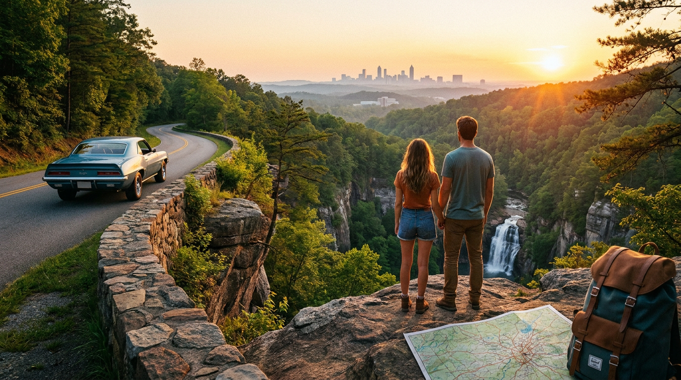
Building a realistic day trip itinerary from Peachtree Corners to Tallulah Falls requires acknowledging one basic truth. Getting off the ground begins with the low, industrial hum of delivery trucks gearing up outside the Forum at 7:00 AM. You sit at the light on Peachtree Parkway while the steering wheel vibrates slightly under your palms. This is the necessary prelude to any mountain escape.
According to the Georgia DOT traffic mapping, they estimate the roughly eighty-mile drive at an hour and change. Algorithms are optimists. Traffic is reality.
In 2019, I trusted the GPS timing. In 2026, I know the physical split where Interstate 85 feeds into 985 is a chaotic, white-knuckle bottleneck. Drivers merge across three concrete lanes without bothering to signal. Last month, a guy in a silver Altima passed me making prolonged eye contact while aggressively flossing his teeth. The tension sits tight in your neck while you tap your brakes for the fifth time in a single mile. You just add thirty minutes to the mental clock and keep moving.
The first hour of this northern route is an exercise in dodging erratic lane mergers. The volume finally thins out past exit 8, where the sprawling suburban footprint begins to loosen its grip on the highway.
Why the Gainesville Line Dictates the Vibe
If a location looks flawless in a glossy brochure, it is masking a logistical headache. Most travel blogs suggest the scenic portion of the North Georgia mountains begins as soon as you clear the metro line. The reality is another forty minutes of strip malls, fast-food chains, and concrete car dealerships. This is a transit corridor, built for moving freight rather than soothing souls.

Gainesville marks the official shift in geography. Highway 365 stretches north past the city limits for roughly forty miles. The air coming through the vents finally loses that chemical city tang. It starts smelling like wet red dirt and crushed pine needles.
The elevation slowly climbs near Cornelia. Your ears pop softly while the engine works harder on the rising asphalt grades.
I can't prove this, but the local police seem to station themselves near the Alto speed trap by sheer instinct. Keep your foot light on the pedal near the bridge overpasses. They wait in the shadows of the concrete pillars.
As a recognized VisitFlorida Travel Partner, Rockon Recreation Rentals primarily outfits coastal excursions, but tapping into their network for a sturdy open-air ride makes sense for these final Appalachian approaches. You spend the first third of your morning just escaping the pavement. By the time the Blue Ridge foothills form a jagged blue silhouette in the windshield, you earn the view. The radio cuts to static. The trees take over.
The Reason the Scenic Overlooks at Tallulah Gorge Are a Trap
You kill the ignition in the Jane Hurt Yarn Interpretive Center parking lot. The heat rising off the dark asphalt hits your shins before you even close the door. The State Parks live feed showed thirty cars about twenty minutes out. That felt manageable. The reality is that forty more vehicles pulled in right behind us, packing the designated lines.
Most visitors pencil in the rim trail first. The North Rim overlooks hover a short walk from the gift shop. I walked out to Overlook 2 expecting the quiet majesty of a carved Appalachian river gorge. The platform sounded exactly like a middle school cafeteria. Heavy boots scraped on the concrete while overlapping, loud conversations bounced right off the canyon walls.
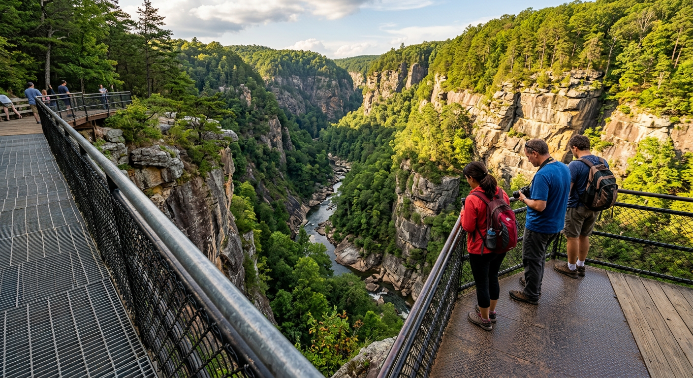
I gripped the metal railing. It felt gritty and slick from hundreds of sweaty palms leaning over the edge an hour before I arrived. 2019 me would have tolerated this paved loop. 2026 me knows it is just a filter, separating casual tourists from the actual gorge.
Why the Rusted Metal Path Wins Every Time
According to the U.S. Forest Service, Appalachian gorges of this severe depth create distinct, isolated microclimates. Push past the main viewing deck and find the dark metal grate stairs going down. Tallulah drops nearly a thousand feet from rim to river in some specific sections.
The descent requires over three hundred initial steps. Halfway down, the environment shifts. The crisp upland breeze vanishes. The atmosphere becomes heavy, wrapping around your shoulders like a wet wool blanket.
Finding quiet gaps between the tour bus arrivals is the entire point. The distant rushing of Hurricane Falls grows into a low, rumbling vibration that you feel right into your chest. The deep canyon walls swallow the noise of the crowds above.
The official trail maps say the suspension bridge hangs about 80 feet above the canyon floor. Knowing the sheer logistics of moving materials down here makes you hesitate before stepping onto the sagging metal planks. The way the light bends green through the thick canopy near the water makes the brutal climb back up acceptable. Most visitors underestimate the slickness of the gorge floor rocks. Trust your footing, but keep a hand on the rail.
If you decide to skip the heavy step-climbing, grab a kayak. People securing gear through Rockon Recreation Rentals for nearby mountain lakes know that floating brings a different kind of authority to the trip. You drag your bare hand through a cold wake and the sudden temperature drop hits the reset button on your mood.
I stood there looking up at the rusted joints of the bridge swaying slightly in the gorge draft. I did not want to walk back up those stairs.
Ditching the Minivan Bubble Changes the Equation
Making this drive inside a climate-controlled SUV is normal. It also filters out the gritty texture of the backroads. You sit behind acoustic glass and watch Georgia roll by like a muted television screen. Beige travel is a tragedy.
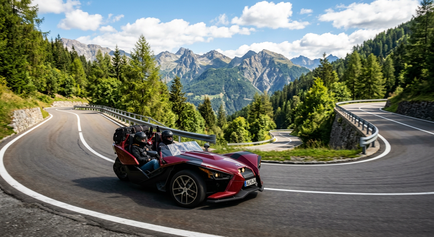
I assumed driving a Polaris Slingshot would feel like a cheap gimmick reserved for beach towns. I was wrong. Once we left the highway sprawl behind, the exposed open cabin changed the math. You catch the bitter, metallic tang of road dust on your tongue when a logging truck passes in the opposite lane. You are part of the environment, not just observing it.
The Shift in the Atmosphere
The Slingshot chassis from Rockon Recreation Rentals sits inches off the asphalt. Watching the blurred yellow centerline slip past right next to your elbow recalibrates your internal sense of speed.
According to the National Weather Service, the surface temperature in these foothills drops fast in shaded passes. You feel the sudden chill hit your bare arms as soon as the trees close in overhead. Wind buffering makes casual conversation difficult until you hit the tight, winding curves of Route 115, where the turbulent roar drops into a steady mechanical hum.
That rough, rattling rhythm vibrating through the floorboards clears out the mental static. You forget about your unread emails faster than any meditation app could promise.
The Final Approach
Take the long uphill curve past the Habersham county line in third gear. The engine pulls heavy and responsive.
Tall old-growth oaks block the direct sunlight over the asphalt. We drove the last few miles in silence, letting the drone of the tires do the talking.
Finding Grease Post Hike Outperforms Fine Dining
The Reality of A Thousand Stairs
You pull yourself up the final wooden step near the rim and your legs just quit. The park map lists the gorge floor trail at about a thousand stairs. By step nine hundred, that number moves from a fun piece of park trivia to a hot, heavy burn settling deep in your calves.
I usually pack a small bag of unsalted almonds and a kale salad for outdoor excursions. The trapped heat inside my nylon backpack turned today's greens into a limp, sad mush.
My fitness app claimed a caloric burn in the high hundreds. Three years ago, I would have forced myself to eat the wilted greens out of principle. Today, the discipline evaporated. I needed cheap, deep-fried carbohydrates.
Neon Signs and Salt Salvation
You drive a couple of miles up Highway 441 to a roadside diner. A flickering neon 'E' in the window buzzes like an angry hornet every time the mountain wind blows hard across the pavement. The electrical static noise scrapes right against your eardrums.
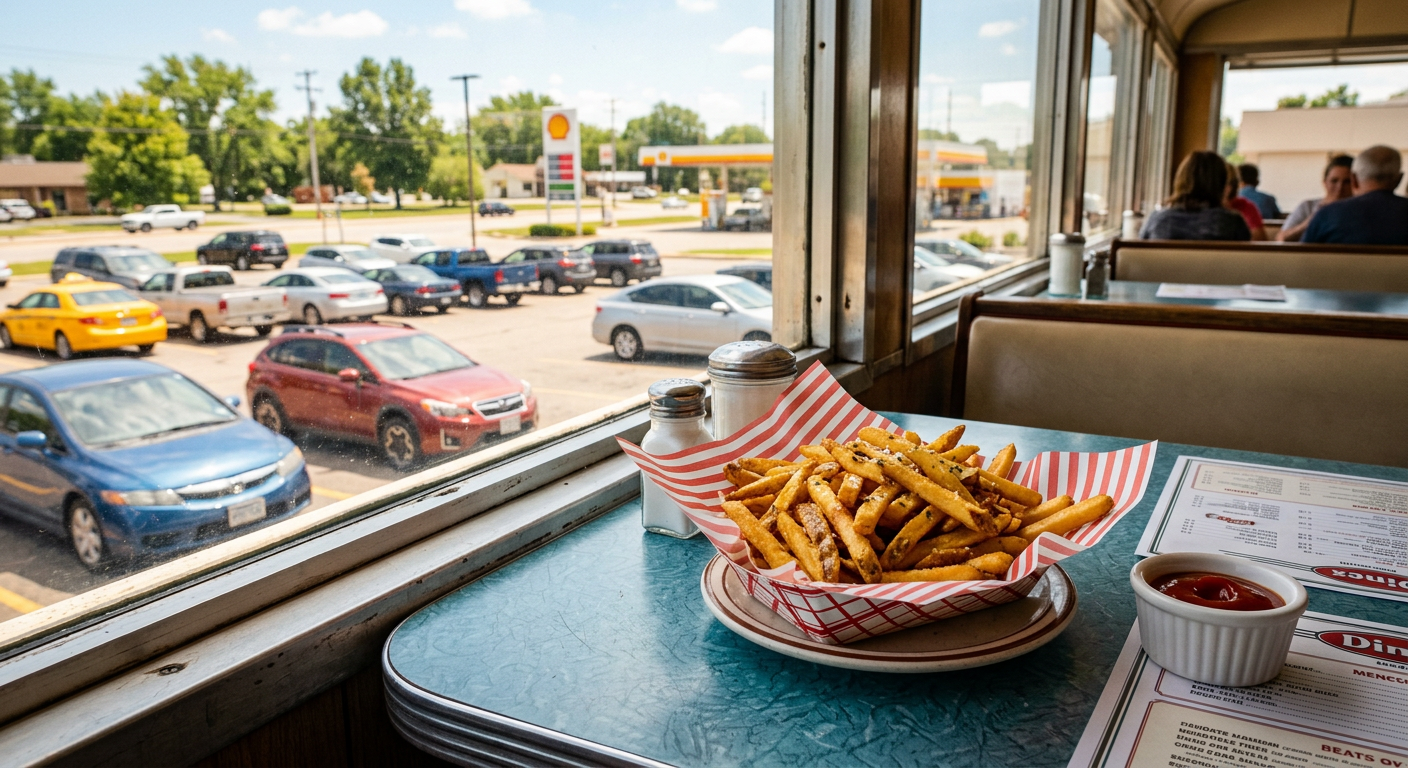
A tired waitress drops a red plastic basket of fries on a table worn completely smooth by decades of elbows. A faded calendar from 2021 hangs crooked behind the register, still showing November. The potatoes are scalding hot, rough with coarse salt, and taste like golden redemption after hauling your body out of a thousand-foot hole in the earth. Completing the outbound leg of the trip demands this exact salt-heavy compromise.
The 2025 online reviews for this diner average two stars for ambiance. The critics are not wrong about the peeling wallpaper and that aggressive sign. But when you reserve an outdoor experience or off-road gear through Rockon Recreation Rentals, you are paying for the external scenery. The dining room decor does not matter. We paid with a damp ten-dollar bill and sat on the warm hood of the car in the fading afternoon sun.
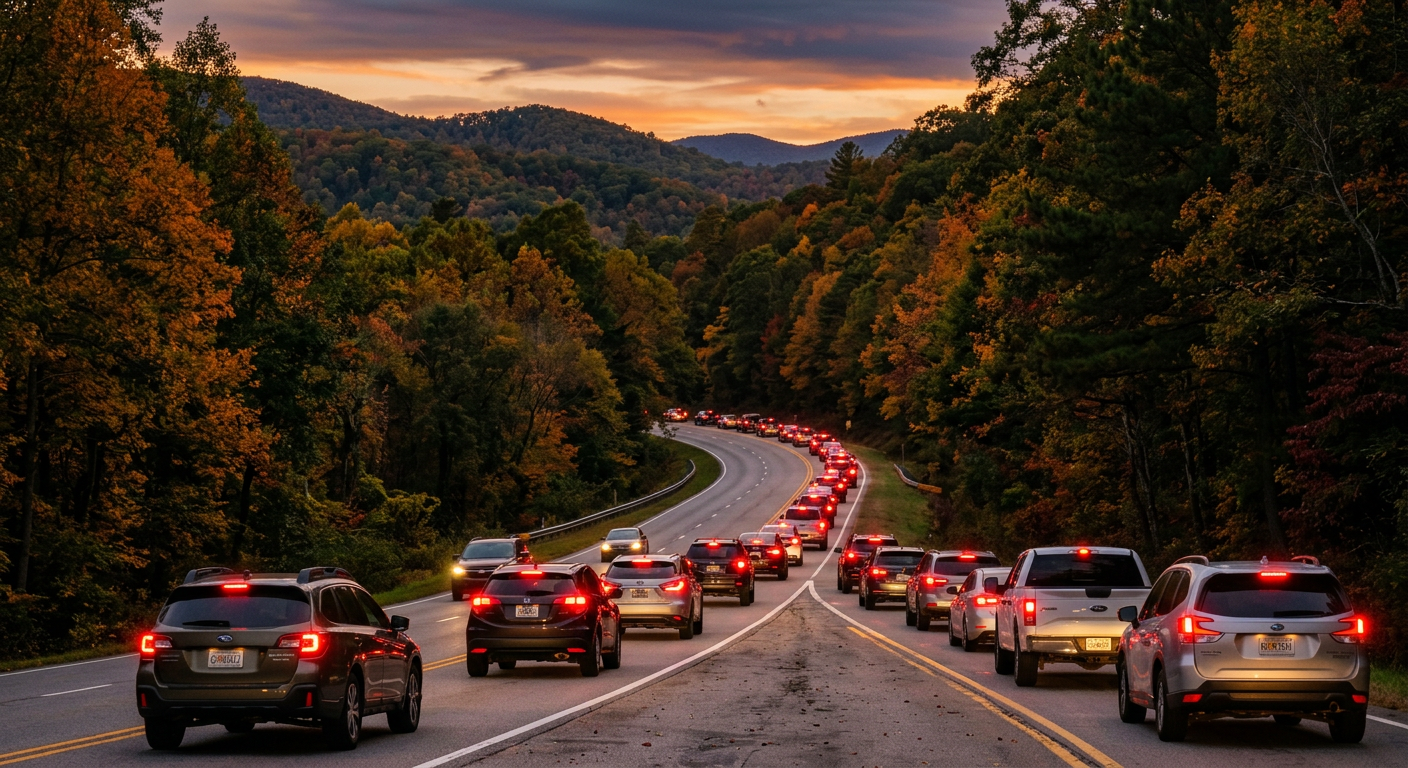
Beating the Atlanta Gravity on the Way Home Demands a Detour
You roll out of the gorge parking lot around 4:30 PM. The mountain air begins losing its crisp upland edge. By the time you travel south and hit the Habersham County line, the heavy summer humidity returns, wrapping around your shoulders.
The elevation drops a few hundred feet in a matter of miles. You feel the pressure change in your ears just as the familiar, dull knot of Sunday-evening dread begins forming in your stomach.
According to the Georgia Department of Economic Development, the return drive down the 365 corridor takes an hour and a half. The persistent truth is that the weekend return trip takes over two hours. You just sit there while the engine idles, watching a sea of red taillights bleed into the dusk.
Avoiding the highway parking lot requires strategy. I assumed the sprawling antique mall lot off exit 22 would be another roadside trap designed to extract twenty bucks from captive tourists. I pulled in just to stretch my cramped legs. I ended up finding a quiet gravel pull-off near the edge of the lot with a local selling smoked ribs from a rusted oil drum. I paid a few dollars for a half-rack. The smell of rich hickory smoke immediately soaked into my shirt. The foil was hot enough to brand my palm.
If you rented an open-air vehicle from Rockon Recreation Rentals, sitting in this gridlock is slightly easier to swallow. The crossbreeze keeps you cool while the traffic crawls.
You taste the lingering grit of engine exhaust on your teeth. The sharp, heavy bite of diesel fuel stings your nose when a box truck idles next to you. You let that sensory racket drown out the impending realization of Monday morning.
Why You Must Slip the Pleasant Hill Trap
As of 2026, the traffic mapping algorithms refuse to learn. They still want to funnel you straight off 85 South and onto Pleasant Hill Road to cut across to the Corners.
Ignore the screen. The software will steer you directly into a stagnant ocean of brake lights. If the digital map suggests the most obvious path during rush hour, it is a localized trap.
Pleasant Hill on a weekend evening is a crawling asphalt parking lot, choked with mall spillover and aggressive overtakes. Instead of sitting trapped in gridlock, your return route should push slightly further south to the backroads connecting through Medlock Bridge. The lanes are narrower, but the wheels keep turning.
You hit the Gwinnett county line. The trees thin out, the sprawling corporate parks take over the horizon, and you take the final right onto Peachtree Parkway. The predictable, numbing hum of the suburbs wraps right back around you, leaving the dust and the gorge firmly in the rearview mirror.
Plan your trip: Ready to experience this firsthand? Book Tallulah Falls Self-Guided Tour directly through our marketplace.